Restoring Native Prairies at San Juan Island National Historical Park

I have mentioned on several occasions that the science conducted in our National Parks is fascinating. One of the main goals of the National Park Service is to maintain the natural habitat of the National Parks. With only 3% of the original prairie existing in western Washington, the preservation and restoration of native plants at San Juan Island National Historical Park is a top priority. This is accomplished by collecting native prairie plant seeds, planting native plants and removing non native plant species:

The windswept landscapes on San Juan Island offer some of the last remnants of native prairies. As Europeans settled into the Pacific Northwest, most prairies were converted into farms and homesteads. At San Juan Island National Historical Park, resource managers are attempting to restore the prairie ecosystem by replacing exotic plant species with native vegetation. This effort benefits not only the plants and animals on the island, but will one day offer visitors a sweeping, unspoiled panorama of Puget Sound as it once existed, hundreds of years ago.

Lees Ferry Grand Canyon National Park Rafting

The official beginning for most Grand Canyon rafting trips is at Lees Ferry (also commonly referred to as Lee’s Ferry or Lee Ferry) in Marble Canyon which gives a wonderful preview of what’s to come with the Colorado River surrounded by magnificent canyon scenery:

Lees Ferry at Marble Canyon -- launching site for Grand Canyon National Park rafting trips

Since this is where the Grand Canyon rafting trips launch, this is where you get your initiation to what the rafting trip will be like. You meet the crew that will be guiding you down the river, are given supplies to keep all your belongings dry on the trip, given a quick course of raft safety and life jacket use, and load all your belongings onto the rafts. While there are some historical buildings and beautiful scenery all around, unless you make a concerted effort to seek them out, you will likely miss them as your focus will be on all the activity to get you on the raft and on your way down the Colorado.

There is quite a bit of history that goes with the Lees Ferry launch site. The ferry was originally built in 1871–1872 by John D. Lee with financing from The Church of Jesus Christ of Latter-day Saints. The ferry was located near where the Colorado River and Paria River merge and the crossing was originally called Paria Crossing. For nearly 50 years, Lees Ferry was the only available crossing of the Colorado River by ferry between Moab and Needles. This made Lees Ferry the main Colorado River crossing point for travelers between Utah and Arizona.

The actual ferry at Lees Ferry closed in 1928 with the building of Navajo Bridge (7 miles to the south) across Marble Canyon. The steel wire cable from the ferry still remains and crosses the Colorado River at the old ferry site. This cable marks the entrance to Grand Canyon National Park as you begin the float trip down the Colorado River. Lees Ferry is currently part of Glen Canyon National Recreation Area and is deemed as a historical site.

Photo courtesy of Li Ru Yue

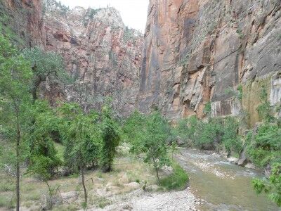
Riverside Walk at Zion National Park

Although a Grand Canyon rafting trip officially begins when you hit the water at Lees Ferry, it unofficially begins when you make your way to Las Vegas. There are options to fly from Las Vagas to Lees Ferry, but I would highly recommend renting a car and driving.

While it’s about a 5 to 6 hour drive from Las Vegas to Lees Ferry, the route allows you to drive through Zion National Park. Planning an extra day or two to explore and play in Zion before a Grand Canyon rafting trip would be an excellent way to begin the entire vacation (while it’s possible to do it after the rafting trip as well, you will have a lot more energy before the trip).

Even if you don’t have the time to give yourself a full day at Zion National Park, it’s still possible to do a short hike while passing through (what we ended up doing). A hike along the Riverside Walk path that takes you to The Narrows (Temple of Sinawava stop) is ideal in this situation since it also requires a trip on the shuttle bus which allows you to see the entire park and gives a quick guided overview of Zion.

The Riverside Walk is a relatively easy 2 mile round trip (about 1.5 hours) on a maintained path that is suitable for wheelchairs and strollers and gives some wonderful views of the North Fork Virgin River:

Riverside Walk in Zion National Park

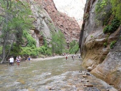
The end of the Riverside Walk path is at the North Fork Virgin River where the beginning of the The Narrows hike begins. This is a much more strenuous hike through the river and requires water shoes (these can be rented at a number of shops just outside the park’s south entrance). You can hike the first few miles of this without a permit, but the entire 16 mile hike up The Narrows does require a permit.

The Narrows at Zion National Park

Black Bear Science at North Cascades National Park

As I have mentioned before, I am always fascinated by the science conducted in our National Parks. When it comes to studying the animals residing inside our National Parks, the most difficult part is often finding them. North Cascades National Park utilizes both hi-tech and lo-tech to get the information they want from their black bear population:

Finding and monitoring bears in rugged Northwest parks has always been dicey. Today, through genetic testing, tufts of bear hair can tell scientists how many animals live in an area, how far they range, and how closely related they are to one another. In this video an NPS biologist demonstrates how to snag bear hair using innovative techniques that include barbed wire, high-tech cameras, and some really stinky scent lure.

Cave Pearl Crystal Cave Sequoia National Park

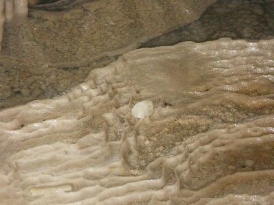
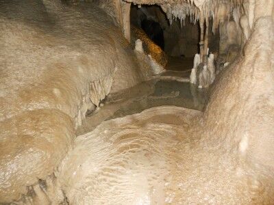
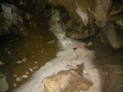
There are several opportunities to see “cave pearls” when exploring Crystal Cave in Sequoia National Park (CA). Cave pearls form when acidic water drips onto grains of sand or tiny stones. The dripping water causes the grains to move so that they do not attach to the cave floor while the calcite within the water causes the grains of sand to grow into bigger pebbles (and then rocks) as more and more calcite covers them. This is a cave pearl found among the rimstone dams in the Fairy Pools formation in the Dome Room at Crystal Cave.

Cave pearl at Fairy Pool in Crystal Cave Sequoia National Park

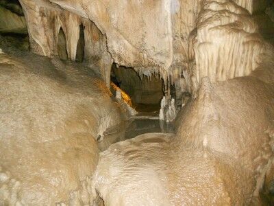
Fairy Pools Crystal Cave Sequoia National Park

My favorite of the many magnificent cave formations at Crystal Cave in Sequoia National Park (CA) was the Fairy Pools. Also located in the Dome Room, these delicate flowstone dam pools are perfectly framed by other cave formations which make them look like they do come out of some type of fairy tale:

Fairy Pools in Dome Room in Crystal Cave at Sequoia National Park

The Fairy Pools are right along the cave path which allows you to inspect them closely (not from a distance as with many of the other popular formation within the cave). This allows you to see up close and personal how calcite makes many different types of cave formations in a single spot:

Lily Pads in the Fairy Pools formation in Crystal Cave

Sea Glass Beach Fort Bragg California

While not technically a National Park (there are a lot of rock outcroppings along the shoreline which are all part of the California Coastal National Monument), Glass Beach in Fort Bragg, CA is definitely worth a visit. It’s not often that you see a beach that is almost entirely made of sea glass (also called beach glass, mermaids tears, lucky glass, ocean glass and sea gems) that is several inches thick in some places:
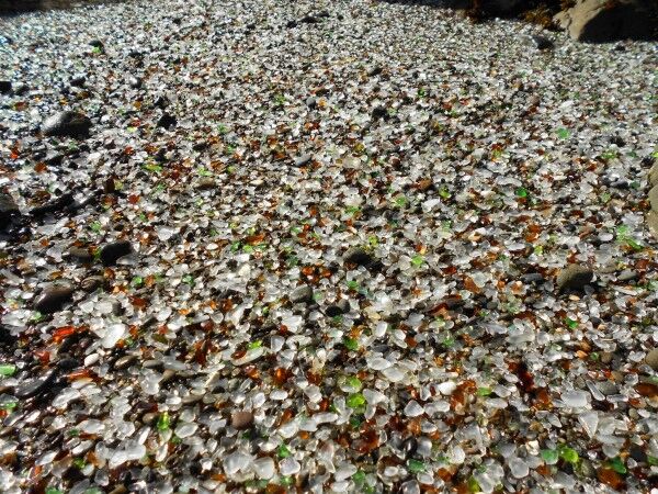
a beach made up almost entirely of sea glass in Fort Bragg, CA

Most people assume that sea glass comes from glass garbage dumped out at sea that eventually makes its way to the shore. In many cases, this is how sea glass arrives on the beach, but not in the case of Glass Beach in Fort Bragg. Instead, the glass has been there for up to 100 years getting churned by ocean waves and sand.

Towns along the sea coast used to dump all their garbage into the oceans. In most areas, the tide would come in and sweep all the garbage out to sea, but the rock formations at Fort Bragg create a unique wave pattern that kept everything on the beach. Basically, all the glass garbage that was dumped in the Fort Bragg dumps from 1906 – 1967 remains where it was dumped and over the years the sand and tides have smoothed the sharp glass into smooth, rounded sea glass pebbles of many different colors making the entire beach a “glass beach.” It also has resulted in Fort Bragg having the highest concentration of sea glass in the world.
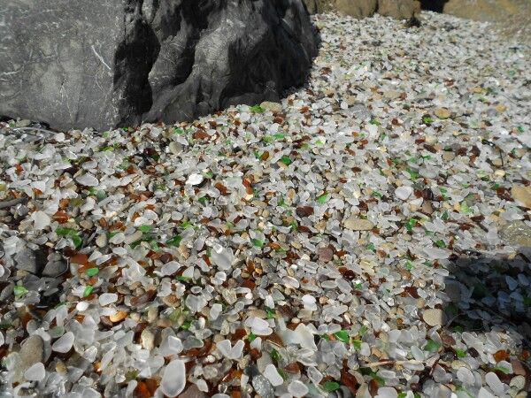
beach glass from Glass Beach in Fort Bragg California

It’s a pretty incredible sight with the sea glass several inches thick in some areas. It also makes for excellent foreground photographs of the California Coastal National Monument outcroppings just off the coast:
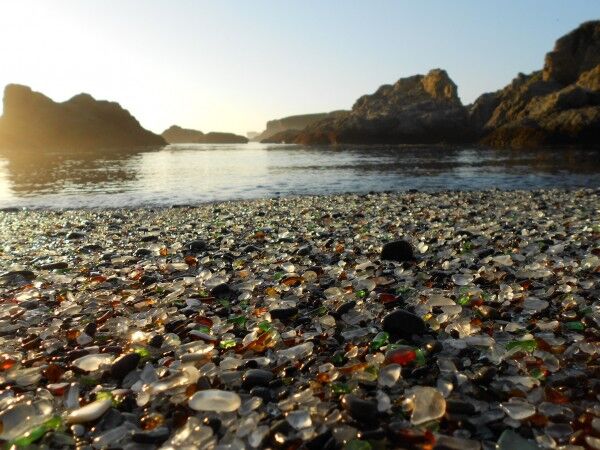
seaglass beach

Here is a short video I took at Glass Beach:

There are actually 3 Glass Beaches in Fort Bragg. The one that is most famous is part of MacKerricher State Park (CA) and was the Fort Bragg dump from 1949 – 1967. I took these photos and video at the 1943 – 1949 dump site which is just south of MacKerricher State Park. There is another dump site that ran from 1906 – 1943, but it’s only accessible by sea kayak.

For those interested in directions how to get to 1943 – 1949 dump site, there is a Glass Beach Museum on highway 1 toward the south end of Fort Bragg where you can get a map of all the glass beaches in Fort Bragg (and see an amazing display of sea glass).
Tidepool Science at Olympic National Park

As I mentioned before, I totally support Research Science in our National Parks. I found this short video called Working Between the Tides on the science of tide-pools at Olympic National Park fascinating. It shows how the National Park service determines the distribution, diversity and abundance of the sea creatures that live in the tidal zone and why the tidal zone is so important as a leading indicator of climate change. It is well worth the 5 minutes it takes to watch:

Scientists at Olympic National Park have only a small window of time to study intertidal communities, the turbulent meeting place between land and sea. In order to work at the lowest summer tides, they often wake at 2AM and hike in the dark to the Pacific coast. This is a place of rich biological diversity, fierce competition, and strong indicators of a changing climate.

Natural Bridge at Natural Bridges State Beach California

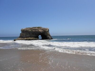
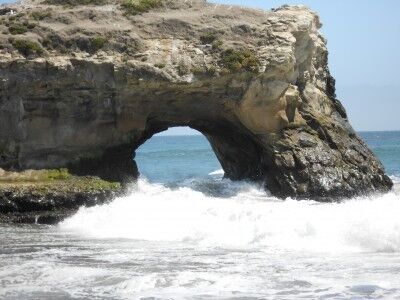
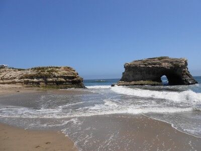
If you are looking for a beach that has more than just sand, Natural Bridges State Beach (CA) is an excellent choice. In addition to Sandy Beach and the Natural Bridge, the beach also has wonderful tide-pools to explore during low tide and is home to one of the largest monarch butterfly over-wintering sites in the Western United States. The beach was named after three natural bridges that extended out into the ocean — now only one remains:

natural bridge at Natural Bridges State Park in California

Waves crashing through Natural Bridge at Natural Bridges State Beach in California

In the early 1900s, three arches carved by nature out of a mudstone cliff inspired the naming of Natural Bridges.

The arches were formed millions of years ago when water, silt and clay sediment combined with one-cell marine plants called diatoms. Heat and pressure solidified the mixture into a soft stone that formed the three arches.

Wave action against the soft rock formed the bridges and also undercut them, eventually wearing them away and leaving only islands. The outermost arch fell in the early part of the 20th century and the inner arch broke during a storm in 1980. Only the middle arch remains, but it is being slowly eroded by the waves.

With the last remaining bridge now fully cut off from the coast, it’s part of the California Coastal National Monument.

Natural Bridges formation at Natural Bridges State Beach in California

I arrived at high tide, so I was not able to explore the tide-pools. I have on other occasions in the past and they are quite interesting and an excellent place to take kids with quite a bit of tide-pool life to see.

The park rangers offer year round guided nature walks on such topics as wildflowers, birds and wetland explorations.

The monarch butterfly natural preserve walkway is currently being worked on, but should be ready when the monarch butterflies return in winter. Monarch butterfly tours are offered at 11:00 am and 2:00 pm on weekends in the fall and winter. The park also offers two special events related to the monarch butterflies: Welcome Back Monarch Day is on the second Sunday in October from 10:00 am to 4:00 pm and The Monarch Migration Festival is the second Saturday in February from 10:00 am to 4:00 pm.