Persistence Cave: Secret Cave at Wind Cave National Park to Be Explored

Persistence Cave explored at Wind Cave National Park

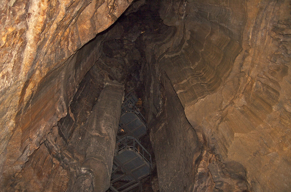
The United States National Park Service (NPS) can keep a secret. In 2004, a worker at Wind Cave national park in South Dakota stumbled upon a new cave in the park. The park service named the cave Persistence Cave but decided to keep the cave a secret from the public to avoid amateur spelunkers from trying to explore, and possibly damage, the cave. The NPS now plans to initiate the excavation of the unexplored Persistence Cave beginning Monday. They hope the information gained will help shed light on the climate changes that have taken place in the region over the last 11,000 years.

In addition to the NPS team excavating the cave will be Jim Mead, a professor at the East Tennessee State University. They are hoping to secure both sediment samples and animal bones from the cave which would offer details regarding the animal species which inhabited the region over the centuries. The team has already done preliminary sample tests at the mouth of Persistence Cave which uncovered the bones of three animal species which had never been known to inhabit the Black Hills area. The three new species found were the pika, the pine marten, and the platygonus.

All the new bones found at the mouth of the cave, along with any new ones excavated during the exploration beginning Monday, will be catalogued and studied. The good news is the study of these 11,000-year-old bones won’t need to be done alone. The scientists plan to study any new finds in conjunction with bones found at the Hot Springs Mammoth Site which is a nearby prehistoric graveyard discovered in the 1970s. The fossils at the Hot Springs Mammoth Site date back 26,000 years allowing the researchers to do quality age comparisons between the two, and noting how the environment and climate have changed in the area since the last glacial period.

For those who want to see the cave, you’re out of luck, at least for now. The NPS is keeping the exact location of Persistence Cave a secret while the excavation and exploration of the cave take place. That begs the question, how did this cave remain unfound for so long when Wind Cave has been explored for more than 100 years? The current theory is that although Persistence Cave is likely linked to Wind Cave, the passage that once connected the two caves has been blocked making it inaccessible to humans from Wind Cave.

(Photo courtesy of daveynin)

Native Americans Yosemite Paiutes Christmas Tree

There is currently a Christmas tree display being hosted at Fresno Yosemite International Airport with the trees being decorated under the theme “celebrating our national parks.” There are thirteen trees in the exhibition in all, and anyone can “like” their favorite tree by going to the airport’s Facebook Page. Voting gives you a chance to win some carry-on luggage in a random drawing at the end of the exhibition. The third tree in the series of thirteen is called “Native Americans: Yosemite Paiutes” which was decorated by Cindy Ainsworth. This was her description of the tree:

“My tree tells the legend of coyote and the sun. For whatever reason, coyote wanted to travel the path that the sun took each day, so he made his way to where the sun came up and rode on the sun all day. By the time the sun was heading down into the trees, coyote was ready to get off and so he climbed off onto a tree.”

Yosemite Paiute Indian Xmas tree

Yosemite native american Xmas tree

John Muir Trail Christmas Tree

If you happen to fly into or out of the Fresno Yosemite International Airport (or you’re in the area and want to visit to take a look), the airport is currently hosting a display of thirteen Christmas trees with the theme of “celebrating our national parks.” As part of the display, you can go online to the airport’s Facebook Page to vote on the Christmas trees that you like the best. Doing so will enter you into a drawing for a chance to win some carry-on luggage. The trees all have different themes chosen by the person who decorated them. Xmas tree #2 is titled “John Muir trail: 211 Miles of Wow” and it was decorated by Wendy Ainsworth. She included the following message:

“I could just picture all the wild things that I would do wrong if I actually went on the John Muir trail hike on foot. So, I created my alter ego to entertain you with ‘what-if’s’ and ‘nah, that can’t be real’…But seriously, I would really like to see the sights by mule back! Just look at the postcards and do your own day-dreaming.”

John Muir national parks Xmas tree

John Muir trail national parks Christmas tree

National Parks John Muir Christmas tree crown

General Grant National Parks Christmas Tree

The Fresno Yosemite International Airport currently has a display of thirteen Christmas trees “celebrating our national parks.” You can visit the airport’s Facebook Page to vote on which of the thirteen trees you like the best and to be entered into a drawing to win some carry-on luggage. Below is tree #1 titled “General Grant” was decorated by DeAnne Lewis Hale with the following message:

“Each December a wreath is laid at the base of the General Grant tree to honor those who gave their lives in the service to our country. This tree is our way of paying tribute to the brave men and women of our armed services.”

national parks Christmas tree General Grant

National Parks Xmas tree General Grant

General Grant Christmas tree topper

Visitors Defecating on Ground Next to Locked Public Restrooms at Death Valley National Park

The national park employees haven’t had the opportunity to say much about the national parks being closed because as federal employees, they aren’t allowed to share their views publicly. realizing that it’s important that the park rangers’ views be heard, NPX films, along with the National Parks Conservation Association (NPCA) set up a way for park rangers to share their views anonymously which they turned into a video entitled “Anonymous Rangers” which is well worth watching and should be passed along to all you know.

The video wasn’t able to incorporate all of the information that the rangers passed along for the project. Some of the information received, but left out of the video include that visitors are defecating on the ground immediately adjacent to locked public restrooms at Death Valley National Park, that visitors are vandalizing park property, and that park staff have received insulting messages including: “F*** you. This is my park. I pay taxes” and “I peed in your parking lot you federal government bastards.”

Our national park rangers deserve better…

anonymous ranger video

9 Amazing Hikes That Will Make You Wish Autumn Came Twice a Year

By Alanna Sobel

Albert Camus once said that autumn was like a second spring, where each leaf became a flower. Nowhere is this as true as within the National Park System, where the coming of fall encourages trees to turn their bounty of foliage into a veritable feast for the eyes with bright oranges, crisp reds, and yellows that shine with anticipation. An epiphany of beauty awaits visitors in an explosion of hues during autumn as nature puts on a dazzling finale.

A brief list of the most gorgeous fall park trails should be on every bucket list.

Autumn hikes
Image courtesy of jay8085

Glacier National Park in Montana offers some of the West’s most impressive autumn vistas and Firebrand Pass, cradled by two climbing mountains, gives visitors a bird’s-eye view of the meadow’s fall palette. Beaver Pond Trail in Yellowstone is the perfect spot to observe wildlife making their winter preparations. Beaver Pond Trail can easily be a day hike, while Firebrand Pass is more difficult and will take more time.

Riprap Trail in Shenandoah National Park contains a portion of the Appalachian National Scenic Trail and takes hikers past private coves of mountain laurel that follow streams within the park. The swimming holes are the main attraction along this trail, especially during warm fall days. While in Virginia, the White Oak Canyon Trail is a must-see as well. Lush forests surround impressive waterfalls, several with natural geological slides.

For those not interested in swimming, Sargent Mountain Loop, located in Acadia National Park, offers its princely hues of golds and bronzes primarily in October. The view of the coastline and Mount Desert Island is impeccable and the hike is just challenging enough to thrill the intermediate hiker. For those that live in the west, the Tuolumne River Loop in Yosemite is a relatively flat hike, perfect for panoramic shots and is a fairly easy hike for beginners. The Puppy Dome and Dog Lake both offer breathtaking scenery perfect for fall photography.

For those with limited mobility or those who are unable to traverse several miles of rocky landscape, the Roaring Fork Motor Nature Trail in Great Smoky Mountains National Park is an ideal way to enjoy the national park. This road trail can be traveled via car, though not motor-home, and takes visitors past swollen fall rivers and historic buildings nestled under canopies of reds and oranges. Also in the Great Smokies, the Oconaluftee River Trail follows the river for 1.5 miles. The clear waters reflect the fall colors of the forest and provide a peaceful escape for those seeking a shorter hike. Lastly, the Blue Ridge Parkway must be included on every list of fall trail escapes. Built to connect Shenandoah National Park to Great Smoky Mountains National Park, the dramatic views of foliage and mountain ridges are truly unforgettable.

Alanna Sobel is a writer for the National Park Foundation, the official charity of America’s national parks. In partnership with the National Park Service, the National Park Foundation enriches America’s national parks and programs through private support, preserving our country’s heritage and inspiring generations of national park enthusiasts. To learn about our national parks or to find out how you help, visit nationalparks.org

List of National Parks that are Open During the Shutdown

As most people are well aware at this point, the vast majority of the parks within the national park system are closed due to the government shutdown. A few states have worked with the government and they have decided to reopened a few parks with state funds. It’s important to note that just because a state has decided to reopen some parks within their state, that doesn’t mean that all of the national parks sites within their state are open. The number of sites open is still only a small percentage of the 401 sites that make up the national park system. Below is the current list of sites that are currently open, along with the dates that they are scheduled to remain open:

Arizona

grand canyon national park arizona

Grand Canyon National Park (currently scheduled to be open from October 12 to 18)

Colorado

rocky mountain national park

Rocky Mountain National Park (currently scheduled to be open from October 11 to 20)

New York

statue of liberty

Statue of Liberty National Monument (currently scheduled to be open from October 12 to 18)

North Carolina / Tennessee

national park

Great Smoky Mountains National Park (currently scheduled to be open from October 16 to 20)

South Dakota

mount rushmore

Mount Rushmore National Memorial (currently scheduled to be open from October 14 to 23)

Utah

Arches National Park

All Utah parks are currently scheduled to be open from October 11 – 20

Arches National Park
Bryce Canyon National Park
Canyonlands National Park
Capitol Reef National Park
Cedar Breaks National Monument
Glen Canyon National Recreation Area
Natural Bridges National Monument
Zion National Park

Sex in National Parks: Where People Are Having It Most

It seems that nature lovers are doing more than admiring nature at our national parks, at least according to a press release survey from MissTravel.com which claims that 1 in 5 travelers have enjoyed sex on America’s public lands. Zion National Park was crowned the top place where couples have done more than explore nature based on the survey of 8,500 traveling singles.

Brandon Wade, Founder & CEO of the website that conducted the survey notes in the press release that “Mother Nature inspires people to shed their inhibitions and give in to their primal urges. At a National Park, there are lots of secluded areas off the beaten path, and it wouldn’t be too difficult to find a quiet, romantic spot for two people to be alone together.”

While the one in five number may at first appear rather high, it’s important to remember that there are some national parks that have hotel lodging and camping within the park. Below are the top 10 parks where people are having sex according to the survey:

Number 1: Zion (Utah)

Zion national park
Photo: Jeffrey Strain

Number 2: Dry Tortugas (Florida)

Dry Tortugas national park
Photo: Richard Lopez

Number 3: Redwood (California)

redwood national park
Photo: Jeffrey Strain

Number 4: Mammoth Cave (Kentucky)

Mammoth Cave national park
Photo: Jeff Kubina

Number 5: Arches (Utah)

Arches national park
Photo: Jeffrey Strain

Number 6: American Samoa (American Samoa)

American Samoa national park
Photo: eutrophication&hypoxia

Number 7: Biscayne (Florida)

Biscayne national park
Photo: Bruce Tuten

Number 8:Big Bend (Texas)

Big Bend national park
Photo: Robert Hensley

Number 9: Congaree (South Carolina)

Congaree national park
Photo: Hunter Desportes

Number 10: Great Smoky Mountains (Tennessee)

Great Smoky Mountains national park
Photo: Carl Wycoff

Route 66 Petrified Forest National Park

As you drive through Petrified Forest national park in Arizona, you’ll reach a highway overpass which separates the painted desert section of the park from the petrified forest area. To the north of this overpass is an unexpected displays on the side of the road which celebrates old Route 66. The old Route 66 used to travel right through Petrified Forest national park, and this small display is a recognition of this part of the park’s past.

There are several parts to the display. The first one you come across is a bench with the back side displaying the bumper and tail lights of an older car:

route 66 car bench bumper

The front side of the cement bench has the Route 66 logo / sign etched into the sitting area:

route 66 car bench

Probably the most prominent part of the display (which seems to catch most people’s eyes as they drive by) is an old, rusted-out car.

route 66 car

route 66 old car

While the bench and the old car are what most people seem to focus on when visiting this display, for me the most interesting part of it was the long, abandoned line of telephone poles. Looking at them shows exactly where Route 66 once ran (if you click on the photo to enlarge it and look closely at some of the distant poles, you can see some still have the glass conductors used for the lines on them)

route 66 telephone poles

This is what the informational sign at the display says:

You are standing near old Route 66. The line of the roadbed and the telephone poles in front of you mark the path of the famous “Main Street of America” as it passed through Petrified Forest National Park. From Chicago to Los Angeles, this heavily traveled highway was not only a road, it stood as a symbol of opportunity, adventure, and exploration to travelers.

A trip from Middle America to the Pacific Coast could take about a week — no interstate speeds here! For many, the journey was not just across miles, it was across cultures and lifestyles — from the most mundane to the exotic. Of course, getting to your destination was important, but the trip itself was a kind of reward. From the neon signs of one-of-a-kind motels to burger and chicken fried steaks of the multitudes of restaurants, from the filling stations that served as miniature oases to gaudy tourist traps, these more than 2,200 miles of open road were magical.

While it’s the unexpected beauty of Petrified Forest national park which makes it one of my favorite parks, I think it’s well worthwhile making this quick stop to learn a little about the history of the park as it relates to those traveling across the US.

Devil’s Golf Course Death Valley National Park

One of my favorite places in Death Valley is the Devil’s Golf Course. A lot of people skip this area because they’re in a hurry to reach Badwater Basin, the lowest point in the continental US at 282 feet below sea level (and all the temporary graffiti that is unfortunately there). While Badwater certainly shouldn’t be missed, taking some time to go down the half-mile dirt road which leads to the Devil’s Golf Course is well worth the time.

One of the most surprising aspects of this area is that the bigger salt crystals aren’t easily broken (there are more delicate crystals which can be found hidden in the crevices which are fragile). From a distance, the large crystals look delicate, but as soon as you touch one you know why this area received the name it did. Not only are they hard, they are sharp and pointy. It’s no coincidence that there are warning signs all around the area letting people know that “a fall cold result in painful cuts or even broken bones.”

devil's golf course

death valley devils golf course

salt flat devils golf course

death valley national park

This is how the information sign in the area describes the Devil’s Golf Course formation:

Crystallized salts composed the jagged formations of this forbidding landscape. Deposited by ancient salt lakes and shaped by winds and rain, the crystals are forever changing.

Listen carefully. On a warm day you may hear a metallic cracking sound as the salt pinnacles expand and contract.

The Death Valley saltpan is one of the largest protected saltpans in North America. Salt continues to be deposited by recurring floods that occasionally submerge the lowest parts of the valley floor. Delicate salt formations are hidden among the harsh and rigid spires. Close inspection may reveal the tiny salt structures. Take care — one curious touch can cause them to crumble.

So if you’re visiting Death Valley, be sure to set aside a little time to visit this area. You won’t regret it.