Hopi Salt Mines Grand Canyon National Park Rafting

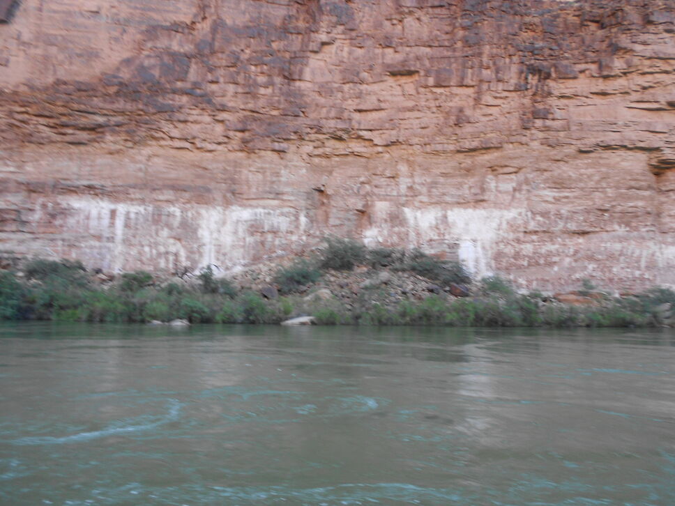
After passing by the Little Colorado River between miles 63.5 and 65 while rafting in Grand Canyon National Park, you begin to see white deposits against the red rock toward the bottom of the Colorado River canyon walls. These are the sacred Hopi Indian salt mines where the Hopi Indians would come to gather salt for seasoning and preserving their food.

Hopi salt mines in Grand Canyon

This area is considered sacred ground and river rafts are not allowed to stop to inspect the salt mines in more detail. In addition to using the salt for everyday uses, a pilgrimage to these Grand Canyon salt mines was traditionally the culmination of a Hopi Indian right of passage bringing males into adulthood.

Humpback Chub Grand Canyon National Park Rafting

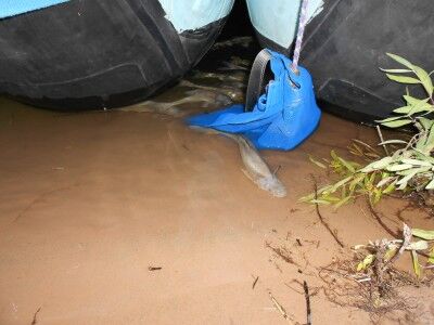
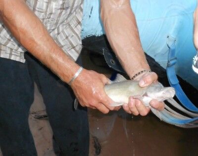
The Humpback Chub is a bottom feeder fish that thrived in the warm waters of the Colorado River before Glen Canyon Dam was built and turned the Colorado River into a much colder river that it is today. It was declared endangered in 1967 and has one of its last strongholds in the Little Colorado River in Grand Canyon National Park. Since the Humpback Chub is protected from fishing, it has learned to recognize the bottoms of the river rafts coming down the Colorado River and gathers around them when they stop to camp near the Little Colorado River. This gives the unique and special opportunity to actually see numerous examples of this endangered fish in the wild:

Humpback Chub gathering around raft in Grand Canyon

endangered Humpback Chub Grand Canyon National Park

Rock Slide Grand Canyon National Park Rafting

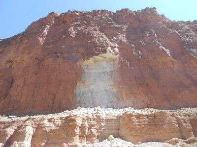
One of the most interesting things I learned while river rafting down the Colorado River in Grand Canyon National Park is that much of the Grand Canyon sandstone isn’t originally red. When you look from the rim of the Grand Canyon down toward the river and see the huge expanse of red sandstone walls, it isn’t difficult to assume that all that color is the original color of the canyon walls. In reality, much of the lower Grand Canyon walls that are red in appearance have simply been stained on the outside by upper layers of the canyon that are red. A perfect illustration of this is the scar left by a recent rock slide within the Grand Canyon we came across after leaving Redwall Cavern:

Grand Canyon rock slide Colorado River rafting

As the rock slide shows, the color of the rock is actually white and not the red of the surrounding rock that has been stained over time. Of course, this newly exposed rock will also eventually get stained to the red we all associate with the Grand Canyon, but I found it interesting to consider what impressions we would all have of the Grand Canyon if it were mostly white instead of red…

Redwall Cavern Grand Canyon National Park Rafting

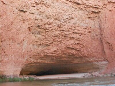
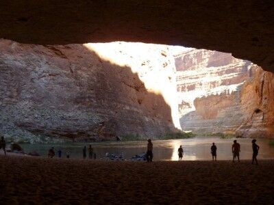
Located between mile 33 and 34 along the Colorado River in Grand Canyon National Park (and just over a mile downriver from Vasey’s Paradise) Redwall Cavern is a giant symphony-sized amphitheater created by the river eroding away the limestone Grand Canyon walls. John Wesley Powell, upon seeing Redwall Cavern, guessed that 50,000 people would fit into it. Although it would be a perfect place to camp, it’s one of the sandbars along the Colorado River where it’s prohibited to camp or build fires.

Redwall Cavern Colorado River rafting

When you land at Redwall Cavern, you will immediately see the fresh feet and tail tracks of countless lizards and other small animals that make their home within the cavern. The wide open space in the shade makes for a perfect place to take out a football or Frisbee to toss around with friends, and it’s a must to walk to the back of the cavern to touch the far wall (this gives you a good perspective on how big Redwall Cavern really is).

Redwall Cavern looking onto the Colorado River
Photo courtesy of Angela Saurine escape.com.au

If you look closely at the rocks toward the front left (when looking out at the river) of Redwall Cavern, you should be able to spot fossils within them. Our guide showed us some and then I spent about half an hour looking at the rocks and found numerous other fossils within the rocks there.

Vasey’s Paradise Grand Canyon National Park Rafting

While it’s possible to hike to Vasey’s Paradise (also called Vaseys Paradise) from Stanton’s cave (only about 1/4 of a mile further away), I chose not to do so. There is thick vegetation at the bottom of Vasey’s Paradise includes the one area in Grand Canyon National Park where poison ivy is abundant, and getting poison ivy was not how I wanted to spend my grand canyon rafting trip. It’s also where the critically endangered Kanab Ambersnail lives.

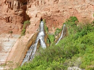
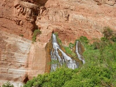
Vasey’s Paradise is the first waterfall on the Colorado River rafting trip which flows year round (there are plenty of waterfalls along the river that are active during flash floods, but quickly dry up). Vasey’s Paradise was named after a botanist who travelled with Powell surveying the river in 1868. The waterfall gets its water from rain that seeps through the upper sandstone layers of the canyon until it hits harder rock where it gathers. It flows out from the upper cliff faces from two cave holes in the canyon wall.

Vasey's Paradise waterfall

This is the first oasis that is seen from the river on the rafting trip, but for the aforementioned reason, isn’t a place where rafts usually stop to explore. It does make for a wonderful contrast to the desert environment as you float past it down the river.

Vaseys Paradise waterfall from Colorado River

Stanton’s Cave Grand Canyon National Park Rafting

With the South Canyon hike thwarted, I decided to try and make my way to Stanton’s cave in Grand Canyon national Park. To make it to Stanton’s cave from our camping area was a short hike downriver toward Vasey’s Paradise after climbing up a rock ridge above the beach. A good pair of hiking shoes is definitely recommended if you want to attempt this hike.

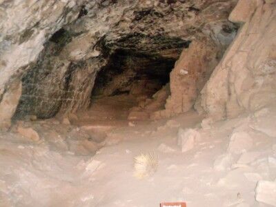
Stanton’s cave is quite large and many artifacts were discovered in it, but it is no longer possible to access the cave as there have been large steel bars placed across its entrance to protect the endangered Townsend’s big-eared bats that live and roost there (This is a good resource if you are looking for more information on the history of Stanton’s cave and bats, and preservation efforts that have taken place over the years). While the cave does first appear to be a former mine and the original signing describes it as such, it’s actually a natural cave.
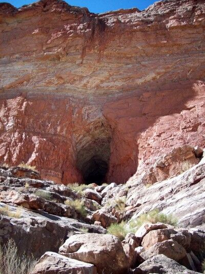
hiking to entrance of Stanton's Cave

view of Stanton's cave through restricting bars

Just inside the bars is a sign explaining why the cave is blocked:
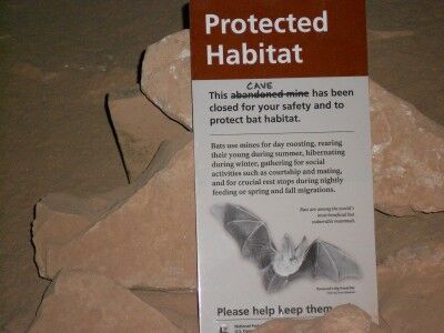
bat sign found in Stanton's Cave

Protected Habitat

This abandoned mine cave has been closed for your safety and to protect bat habitat.

Bats use mines for day roosting, rearing their young during summer, hibernating during winter, gathering for social activities such as courtship and mating, and for crucial rest stops during nightly feeding or spring and fall migrations.

Bats are among the world’s most beneficial but vulnerable mammals. Townsend Big-Eared Bat

The hike to Stanton’s cave is about half a mile (1 mile round trip) from the South Canyon camping beach. It does require some rock scrambling to get up to the ridge above the beach. A path is well worn to the cave, but you do need to be cautious while walking it as there are quite a few loose rocks. Simple head in the direction of Vasey’s Paradise. You may also spot big horn sheep while hiking to the cave (I did).
Navajo Bridge Grand Canyon National Park Rafting

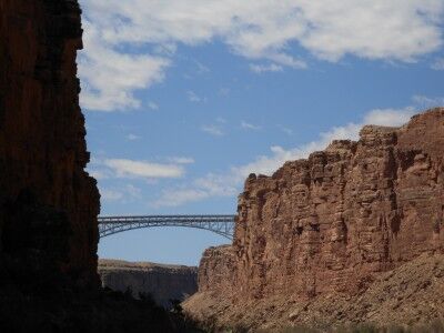
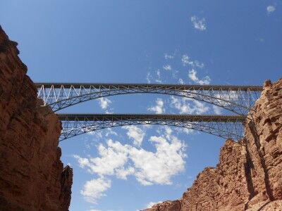
Once you have started the rafting trip through Grand Canyon National Park at Lees Ferry, one of the first landmarks you see is Navajo Bridge. Navajo Bridge is located between miles 4 and 5 from where you started, but can be seen well before you actually reach it.

Navajo Bridge Grand Canyon rafting trip

There are actually two Navajo Bridges that span Marble Canyon today. Construction on the original Navajo Bridge (upriver) began in 1927 and the bridge officially opened to traffic in 1929. This bridge is 834 feet in length and reaches 467 feet in height from the Colorado River at the Marble Canyon floor. The opening of the original Navajo Bridge fostered in the closing of Lees Ferry which had been the only way to cross the Colorado River in the vicinity up to that point.

A newer Navajo Bridge (downriver) was built to accommodate increased highway traffic with heavier loads and was completed in September, 1995 at a cost of about $15 million. The newer bridge is 909 feet in length and reaches 470 feet in height from the Colorado River at the Marble Canyon floor. It was constructed next to the original bridge with a similar visual appearance, but updated to conform to modern highway codes. The original Navajo Bridge was then turned into a pedestrian bridge with an interpretive center nearby which explains the history of the bridge and the early crossings of the Colorado River.

two Navajo Bridges spanning Marble Canyon

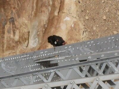
When passing under the Navajo Bridges while on a Colorado River rafting trip through the Grand Canyon, it’s worthwhile to look closely at the bottom of the bridges (definitely take out your binoculars if you brought them). California condors have been reintroduced to the Marble Canyon area and one of their favorite resting places is in the bridge beams under the Navajo Bridges.

California condor in Marble Canyon

California condor on Navajo Bridge photo courtesy of CanyonCountry